Digital Cartographies of the Roman Campagna

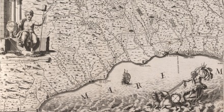
Cingolani della Pergola, Topografia Geometrica dell'Agro Romano, 1704. Image courtesy of the British School at Rome Library.
This project - a collaboration between researchers at ANU, La Trobe University and the British School at Rome - examines the relationship between artistic depictions and imagery of the Roman Campagna (the flat plains of the countryside around Rome more or less coinciding with the modern region of Lazio today) and the place itself, in the context of ecology, climate change, disease and social history from 1600 to 1900. The popularisation of the Roman Campagna as a subject for painting was almost entirely due to the landscape paintings of Claude Lorrain, whose example inspired generations of artists to follow in his footsteps and paint this landscape. However no-one to date has examined his artistic legacy in the light of the nature of that specific landscape. The digital platform being developed will enable a new analysis of the spatial and temporal relationships between art and place in the Campagna, in order to reveal important connections between social and environmental conditions in this landscape, and the imagery of the artists painting and drawing it.
The two historic maps that form the basis of this digital platform are Giacomo Filippo Ameti’s Il Lazio con le sue conspicue strade antiche (made in 1693) and Battista Cingolani della Pergola’s Topografia Geometria dell’Agro Romano (made in 1704), both held in the British School at Rome library. Together they cover the full geographic extent of the Campagna. By geo-referencing these maps and other digital resources, the project is developing a rich spatial databas, that will allow a juxtaposition of the long artistic tradition of painting the Campagna, with the lived experience of that environment.
Contact: katrina.grant@anu.edu.au


